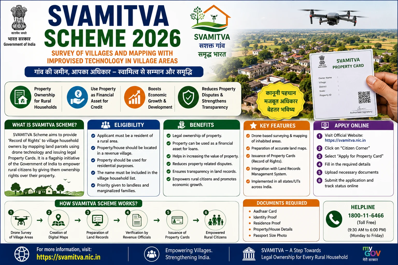
The SVAMITVA Scheme (Survey of Villages Abadi and Mapping with Improvised Technology in Village Areas) is a flagship Central Sector Scheme launched by the Ministry of Panchayati Raj, Government of India to provide legal ownership records to rural property owners. The scheme uses drone-based surveys, GIS mapping, and Continuously Operating Reference Stations (CORS) technology to prepare accurate maps of residential properties in rural inhabited (Abadi) areas and issue Property Cards (Sampatti Cards) to eligible owners.
The primary objective of the scheme is to reduce property disputes, improve land record management, enable villagers to use their properties as financial assets for bank loans, and strengthen rural governance. The scheme is implemented jointly by the Ministry of Panchayati Raj, Survey of India, State Revenue Departments, and State Panchayati Raj Departments.
As of 2026, drone surveys have been completed in more than 3.29 lakh villages, over 3.10 crore Property Cards have been prepared, and more than 2.65 crore Property Cards have been distributed across India. The scheme has also been extended until September 2026 to complete the remaining villages.
This comprehensive guide explains everything about the SVAMITVA Scheme 2026, including eligibility, benefits, Property Cards, required documents, survey process, application procedure, and FAQs.
Objectives of SVAMITVA Scheme
The scheme aims to:
- Provide legal ownership records for rural residential properties.
- Reduce property-related disputes.
- Modernize rural land records.
- Promote digital mapping using drone technology.
- Improve transparency in property ownership.
- Enable villagers to obtain bank loans using property.
- Strengthen Gram Panchayat planning.
- Improve property tax assessment.
- Promote rural economic development.
- Support Digital India and e-Governance initiatives.
SVAMITVA Scheme 2026 Highlights
| Particular | Details |
|---|---|
| Scheme Name | SVAMITVA Scheme |
| Full Form | Survey of Villages Abadi and Mapping with Improvised Technology in Village Areas |
| Launch Year | 2021 (Nationwide Rollout) |
| Ministry | Ministry of Panchayati Raj |
| Implementing Agencies | Ministry of Panchayati Raj, Survey of India & State Governments |
| Beneficiaries | Rural Property Owners |
| Major Benefit | Property Card (Record of Rights) |
| Technology Used | Drone Survey, GIS & CORS |
| Application Mode | Through State Authorities |
What is a SVAMITVA Property Card?
A Property Card (Sampatti Card) is an official ownership document issued under the SVAMITVA Scheme after a successful drone survey and verification process.
The Property Card contains:
- Property Owner’s Name
- Property Identification Number
- Property Boundaries
- Survey Details
- Digital Map Reference
- Ownership Record
The card provides legal documentation of ownership as per the applicable state rules and can be used for various administrative and financial purposes.
Benefits of SVAMITVA Scheme
The scheme offers several benefits to rural property owners.
Legal Ownership Records
Eligible villagers receive official Property Cards establishing ownership records for residential properties in Abadi areas.
Reduced Property Disputes
Accurate drone mapping and boundary verification help minimize land and property disputes.
Easier Access to Bank Loans
Property owners may use their documented property ownership to improve access to institutional credit, subject to lender policies.
Improved Property Records
The scheme creates a digital database of rural properties.
Better Village Planning
Gram Panchayats can use accurate GIS maps for infrastructure planning and development.
Transparent Property Mapping
Drone technology ensures highly accurate mapping of village properties.
Increased Property Value
Official ownership documentation may improve the marketability and legal certainty of rural properties.
Major Benefits to Citizens
The scheme helps citizens by providing:
- Legal Property Card
- Digital Property Records
- Accurate Property Mapping
- Reduced Litigation
- Better Access to Credit
- Transparent Ownership Records
- Faster Property Verification
- Improved Public Services
Eligibility Criteria
Applicants should generally satisfy the following conditions:
- Must be a resident of a notified rural village.
- Must own a residential property in the village’s Abadi area.
- Property should fall within the area covered under the SVAMITVA survey.
- Ownership must be verified according to State Government procedures.
- Must satisfy eligibility conditions prescribed by the concerned State Government.
Eligibility may vary slightly from state to state.
Documents Required
Applicants should generally keep the following documents ready:
- Aadhaar Card
- Identity Proof
- Address Proof
- Mobile Number
- Property Ownership Details (if available)
- Panchayat Records (where applicable)
- Revenue Records (if applicable)
- Passport-size Photograph
Additional documents may be required by the State Government.
How Does the SVAMITVA Survey Work?
The implementation process generally includes the following steps:
Step 1
Selection of villages under the scheme.
Step 2
Drone survey conducted by the Survey of India.
Step 3
Preparation of digital village maps.
Step 4
Property boundary verification.
Step 5
Public display of draft maps.
Step 6
Objection and dispute resolution by the competent State authorities.
Step 7
Final approval of property records.
Step 8
Generation of Property Cards.
Step 9
Distribution of Property Cards to eligible property owners.
How to Get a Property Card
Property owners generally do not need to submit an individual online application once their village is selected.
The process usually involves:
- Village selected under SVAMITVA.
- Drone survey completed.
- Property verification conducted.
- Objections resolved.
- Final ownership records prepared.
- Property Card issued by the State Government.
The exact distribution process may differ across States.
Technology Used Under the Scheme
The SVAMITVA Scheme uses advanced technologies including:
- Drone Survey
- GIS Mapping
- CORS Network
- Digital Mapping
- Satellite Positioning
- Property Digitization
- Geo-referenced Maps
These technologies ensure accurate and transparent property mapping.
Progress of the Scheme in 2026
The scheme has achieved significant milestones across the country.
Key updates include:
- Drone surveys completed in more than 3.29 lakh villages.
- More than 3.10 crore Property Cards prepared.
- Over 2.65 crore Property Cards distributed to rural property owners.
- The scheme has been extended until September 2026 to complete the remaining notified villages.
Major Features of SVAMITVA Scheme
Some important features include:
- Drone-based property survey.
- GIS-enabled digital mapping.
- Legal Property Cards.
- Transparent ownership records.
- Digital land management.
- Improved rural governance.
- Reduced property disputes.
- Better access to institutional credit.
- Scientific property demarcation.
- Nationwide implementation.
Common Reasons for Delay in Property Card Issuance
Property Card distribution may be delayed due to:
- Boundary disputes.
- Pending ownership verification.
- Objections filed during public verification.
- Incomplete survey.
- Revenue record mismatch.
- Administrative verification.
Why is the SVAMITVA Scheme Important?
The SVAMITVA Scheme is transforming rural governance by providing millions of villagers with documented property ownership. It improves legal certainty, strengthens Gram Panchayat planning, enhances transparency in rural land records, and enables property owners to use their assets more effectively for economic opportunities. By combining drone technology with digital mapping, the scheme is creating one of the world’s largest rural property digitization programmes.
Frequently Asked Questions (FAQs)
What is the SVAMITVA Scheme?
SVAMITVA is a Central Sector Scheme that provides Property Cards to rural property owners through drone-based surveys and digital mapping.
Who implements the scheme?
The scheme is implemented by the Ministry of Panchayati Raj, Survey of India, and the respective State Governments.
What is a Property Card?
A Property Card is an official ownership record issued after verification of rural residential properties under the SVAMITVA Scheme.
Is there an online application?
Generally, no separate online application is required. Property Cards are issued after the survey and verification process in notified villages. The process is managed by the concerned State Government.
Can Property Cards help in getting bank loans?
Property Cards can help establish ownership records, which may assist eligible owners in accessing institutional credit, subject to the lending institution’s policies.
Which technology is used under the scheme?
The scheme uses Drone Survey, GIS Mapping, and CORS technology for accurate mapping and demarcation of rural properties.
Is the scheme active in 2026?
Yes. The scheme continues to be implemented and has been extended until September 2026 to cover the remaining notified villages.
Conclusion
The SVAMITVA Scheme 2026 is a landmark initiative that is modernizing rural property ownership through drone technology, GIS mapping, and digital land records. By issuing Property Cards to eligible rural property owners, the scheme helps reduce disputes, strengthens property rights, improves access to financial services, and supports better village planning. With the scheme extended until September 2026 and millions of Property Cards already distributed, SVAMITVA is playing a vital role in empowering rural citizens and building a transparent, technology-driven land governance system in India.
Read More: Bihar Organic Farming Promotion Scheme 2026: Subsidy, Eligibility, Benefits & Apply Online